
Join us for our first endurance ride of the season in beautiful Birds Hill Provincial Park.
We will be offering non-competitive intro rides of 10 or 15 miles as well as a competitive 25-mile limited distance ride and 50-mile endurance ride.
The 25 and 50 mile divisions are AERC sanctioned.
Registration is now open! Register here: https://zfrmz.com/3lLJ9b0F09aH780TRBYv
We will be capping at 30 riders/day, so get those entries in.
A negative coggins from within 6-months is required for this ride. Proof of negative coggins must be submitted by the ride date.
Ride Manager: Darice Whyte
Day Manager May 11th: Carrie Schellenberg-Wilson
Day Manager May 12th: Wendy Carnegie/Dianne Borger
Ride vet: Dr. Glenn Sinclair
Trail Marker: Christine Steendam
The Facebook event page can be found HERE
Just a few reminders.
1) Take all of your poop out with you. We are using the Folk Festival site again and it’s a privilege for us so let’s not forget that. Before you leave ensure all your poop has been cleaned up.
2) Remember to use trail etiquette. Call out if you’re coming up behind other riders so you don’t spook their horse and use caution at intersections as BHP has plenty of other users.
3) We don’t know if the tap will be turned on at the site so bring your sponging water. There will be water for drinking but not for sponging.
4) Don’t forget your park pass as you will need one.
More details including ride times and trails to follow.
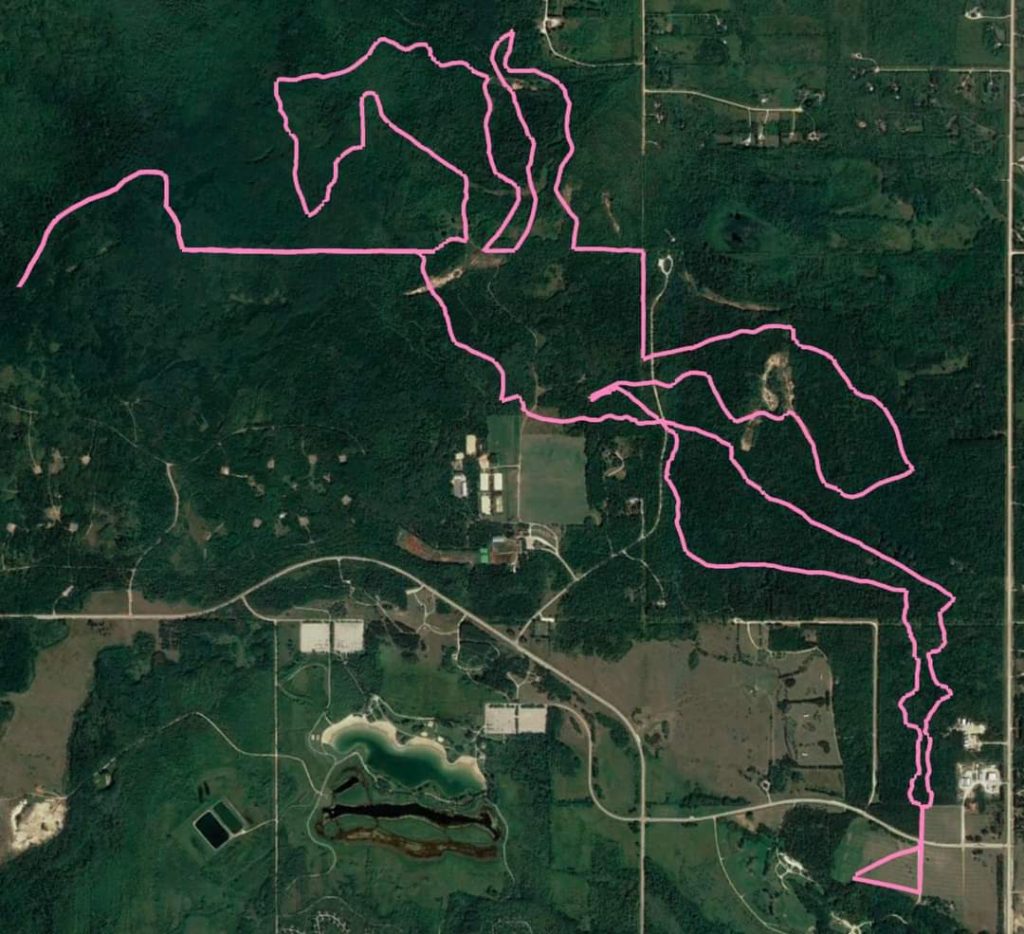
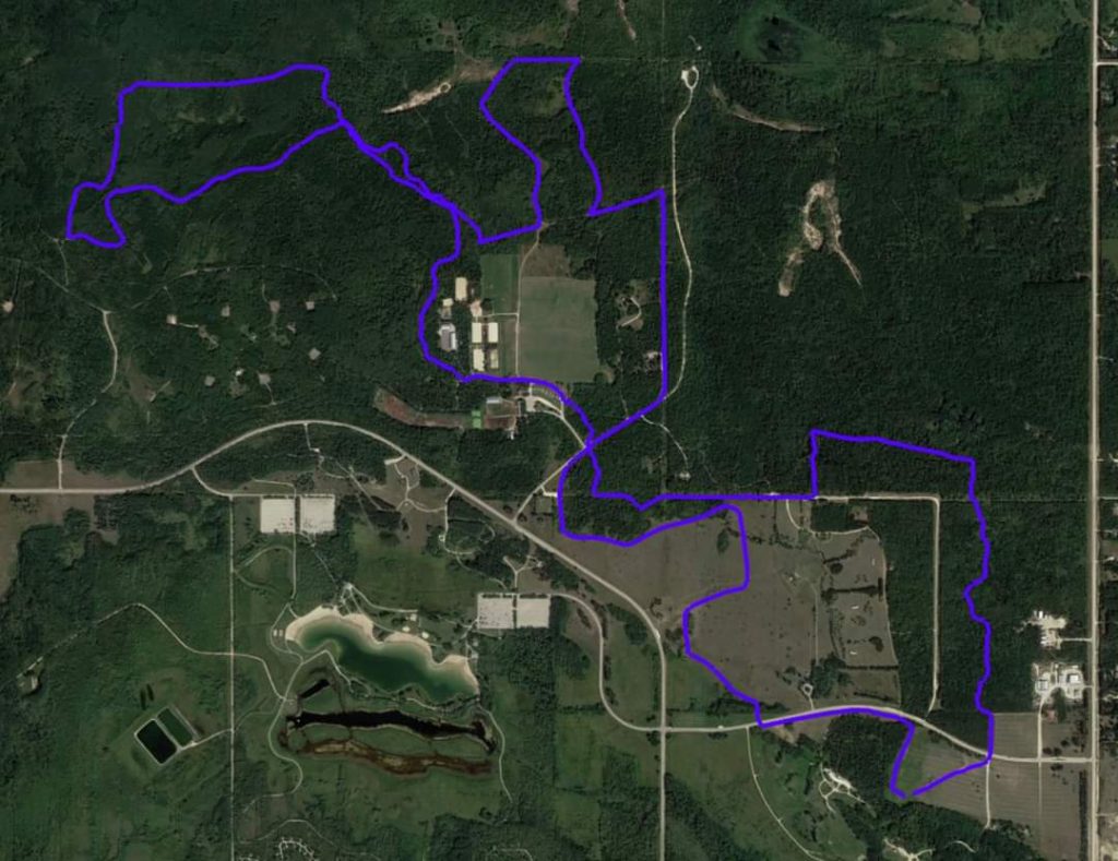
Trail Notes
15 mile loop – pink ribbons
10 mile loop – blue ribbons
Right turn – red ribbons
Left turn – green ribbons
Ribbons will be on your right-hand side with one exception on the 10 Mile loop. Follow the directions and it will be clear.
Unfortunately, trail sabotage is common in birds hill park and sometimes ribbons are removed. Because of this we ground sprayed the turns.
15 mile loop – Pink
Head east from ride camp, turn left at the gravel road heading North towards Festival Drive cross the paved road and head across the field and into Bridle Path (Horse & Rider on Red markers). You’re going to stay on Bridle Path until it comes to Nimowin Road (no sign here), cross the gravel road and take a slight right to continue following Bridle Path.
The trail will take you on a sharp right turn (almost a U turn) and then you will head East on Hazelnut (3 Leaves on Green markers), back across Nimowin road. Stay on Hazelnut. There will be a left turn BEFORE the cabin. If you make it to the cabin, you missed your turn. You’ll go through some yellow barricades and continue on the trail back to Nimowin Road where you will once again cross and then take a right turn onto the Roscoe Road trail (gravel, no markers).
On the Roscoe Road trail you will find your 5-mile marker. You will make a left-turn and then after a ways there will be a right onto Spruce Trail (Pine tree on White markers – used for dog sledding in winter). Follow this trail all the way until you reach a sharp left turn into a BUSHY trail. Follow this until you pop out onto Tamarack Trail (Pine tree on Yellow markers). Make a left turn onto Tamarack.
You’ll make a right turn followed by another sharp right (almost a u-turn) onto Lime Kiln Trail (Kiln looks like a round hut on Blue markers).
From here you will be on the Lime Kiln trail backwards (ie. the blue markers will be facing the other way). Make a slight left to remain on the Lime Kiln trail. You’ll pass a cabin on your left with an outhouse (no guarantee of TP) and the old lime kiln on your right (it is overgrown but it has a placard) . Continue to follow this trail all the way around until it connects with itself–you will make a right turn here to remain on Lime Kiln Trail.
Follow the ribbons through the old manure mounds into some grassy and bushy trail and you’ll pop out at an intersection, stay straightish to enter Mosquito Alley. There will be TWO-WAY TRAFFIC here. You’ll find your 10-mile marker on Mosquito Alley.
Go to the end of Mosquito Alley, turn around in the keyhole loop, and head back the way you came. Follow Mosquito Alley back, you’ll make a slight right where you entered Mosquito Alley at the end of the two way track and remain on the trail until you come to a left turn, it will take you across Lime Kiln both ways and you take a left turn almost immediately followed by a right and another left that will take you out into North side of the practice field behind the Polo Field.
Head East across the field onto Carriage Way (Horse & Carriage on Pink markers), follow Carriage Way to Nimowin Road (gravel), take a right along Nimowin Road followed by a left to continue on Carriage Way. This is approx 2 miles from camp.
You’ll make a right to remain on Carriage Way and take that trail all the way to a left turn onto a small section of gravel, followed by a right turn into the field just outside the East Gate.
Head south along the field to Festival Drive, cross the road (paved) and make a slight right onto the gravel road into camp and head straight in.
10-mile loop – Blue
Head North out of camp towards Festival Drive and there will be a left turn into the trees and onto Bridle Path (Horse & Rider on Red markers) that runs along Festival Drive. Ride along Festival Drive until you come to a right turn that takes you across the paved road and into the trees on the other side, heading North.
Through the trees you’ll follow your blue ribbons up by the water feature and “bridge to nowhere” and across the backside, then take a right turn towards Pope’s Hill. Go along that path until you make a left turn that takes you North across the field again and towards the treeline.
You will take a left turn into the trees and follow the trail and the treeline West until you have a right turn that will take you behind the Cemetery. You’ll ride along the treeline, then cut across Nimowin Road (paved) towards the Ranch, duck into Carriage Way (Horse & Carriage on Pink markers) on your right side which will take you into the Ranch. Cut straight across the parking lot and follow the road past the Polo Field on the black gravel road until you are in the bush again where you’ll have a left-hand turn onto Esker trail (Hill on Yellow markers) followed by a quick right (this is also the start of Lime Kiln trail- looks like a round hut on Blue markers).
Stay on the Esker trail, you’ll come across your 5-mile marker on this trail. You will NOT go all the way back to the Ranch, instead, you will turn left at an intersection that will bring you to a small common stretch with Pink ribbons. Do NOT follow Pink, watch for your BLUE ribbons and keep going straight across Tamarack trail (big dirt intersection with signs for Hwy 59, etc.) until you come to a left turn that takes you North into a wide bush trail.
Follow that for two slight right turns followed by a sharp-right turn heading back South. Next, you’ll make a left(two track with grass and gravel), then a right onto the Roscoe Road trail (lots of stone at the start then grass footing) and follow that straight until it comes out by the Park Office and a paved road.
Follow the paved road until it dumps you onto Nimowin Road (paved to the right, gravel to the left). This is approx 2 miles from camp. Take the paved road to the RIGHT and follow that towards the Ranch driveway. Take a LEFT into the bush onto Carriage Way trail and follow that to the paved keyhole. KEEP LEFT along the treeline – this is the only place that ribbons will be on the left until you get to two boulders and turn LEFT into the bush again. Ribbons will resume on your right side. Next turn Right onto Carriage Way (you will see both Blue & Pink ribbons from this point onwards as both trails come in the same way for this ride) and follow that to the T junction at the small section of gravel, turn LEFT, followed by an immediate Right turn into the field just outside East Gate, cross Festival Drive (paved) and take a slight right onto the gravel road back to camp.