Join us for our last endurance event of the season in beautiful Birds Hill Provincial Park.
We will be offering non-competitive intro rides of 10 or 15 miles as well as a competitive 25-mile limited distance ride and a 50-mile endurance ride each day.
The 25 and 50 mile divisions are AERC sanctioned.
Registration is now open! Register Here
We will be capping at 30 riders/day, so get those entries in.
No Coggins test required! As this event occurs well after the end of the tabanid season, a negative coggins is not required.
Ride Manager: Andy Dunlop
Day Manager: Kelli Hayhurst
Ride vet: Dr. Glenn Sinclair
Trail Marker: Christine Steendam
The Facebook event page can be found here:
https://facebook.com/events/s/birds-hill-boogie-endurance-ri/1490558642113773/
Just a few reminders.
1) Take all of your poop out with you. We are using the Folk Festival site again and it’s a privilege for us so let’s not forget that. Before you leave ensure all your poop has been cleaned up.
2) Remember to use trail etiquette. Call out if you’re coming up behind other riders so you don’t spook their horse and use caution at intersections as BHP has plenty of other users.
3) The tap on site will most likely not be turned on, but we will have the water cube there to fill your buckets for drinking and sponging. I always recommend bringing equine drinking water from home if your horse is fussy about changes to their water. Please bring human drinking water.
4) No park pass is required for 2025.
Ride Times both days:
With sunrise just before 8am and sunset at 6:30, ride times will be as follows:
50’s vet in at 7:30am and we expect to start between 8 and 8:30am depending on number of entries.
25’s will vet in at 8:30 and start at 9:30.
Intro’s to vet in at 9:30 and start at 10:30.
Trail Notes
15 mile loop – pink ribbons
10 mile loop – blue ribbons
Right turn – red ribbons
Left turn – green ribbons
Ribbons will be on your right-hand side with one exception on the 10 Mile loop. Follow the directions and it will be clear.
Unfortunately, trail sabotage is common in birds hill park and sometimes ribbons are removed. Because of this we ground spray the turns.
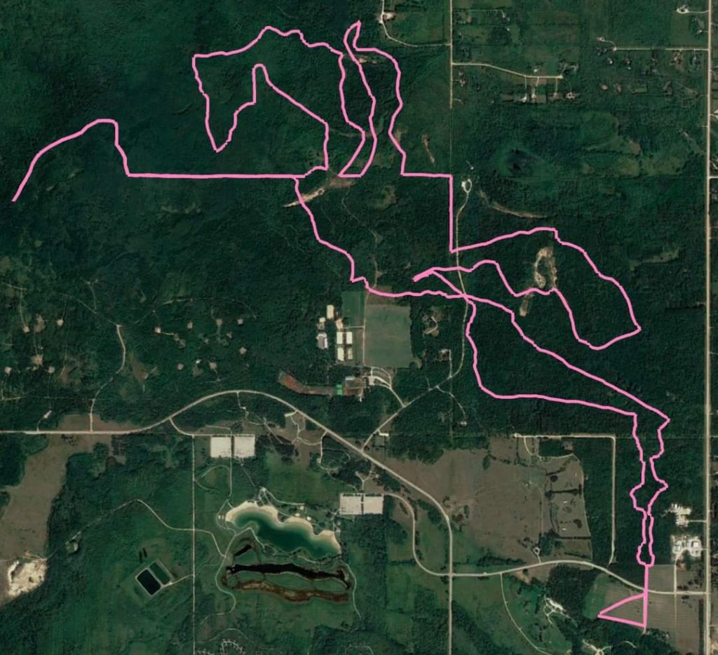
15 mile loop – Pink
Head east from ride camp, turn left at the gravel road heading North towards Festival Drive cross the paved road and head across the field and into Bridle Path (Horse & Rider on Red markers). You’re going to stay on Bridle Path until it comes to Nimowin Road (no sign here), cross the gravel road and take a slight right to continue following Bridle Path.
The trail will take you on a sharp right turn (almost a U turn) and then you will head East on Hazelnut (3 Leaves on Green markers), back across Nimowin road. Stay on Hazelnut. There will be a left turn BEFORE the cabin. If you make it to the cabin, you missed your turn. You’ll go through some yellow barricades and continue on the trail back to Nimowin Road where you will once again cross and then take a right turn onto the Roscoe Road trail (gravel, no markers).
On the Roscoe Road trail you will find your 5-mile marker. You will make a left-turn and then after a ways there will be a right onto Spruce Trail (Pine tree on White markers – used for dog sledding in winter). Follow this trail all the way until you reach a sharp left turn into a BUSHY trail. Follow this until you pop out onto Tamarack Trail (Pine tree on Yellow markers). Make a left turn onto Tamarack.
You’ll make a right turn followed by another sharp right (almost a u-turn) onto Lime Kiln Trail (Kiln looks like a round hut on Blue markers).
From here you will be on the Lime Kiln trail backwards (ie. the blue markers will be facing the other way). Make a slight left to remain on the Lime Kiln trail. You’ll pass a cabin on your left with an outhouse (no guarantee of TP) and the old lime kiln on your right (it is overgrown but it has a placard) . Continue to follow this trail all the way around until it connects with itself–you will make a right turn here to remain on Lime Kiln Trail.
Follow the ribbons through the old manure mounds into some grassy and bushy trail and you’ll pop out at an intersection, stay straightish to enter Mosquito Alley. There will be TWO-WAY TRAFFIC here. You’ll find your 10-mile marker on Mosquito Alley.
Go to the end of Mosquito Alley, turn around in the keyhole loop, and head back the way you came. Follow Mosquito Alley back, you’ll make a slight right where you entered Mosquito Alley at the end of the two way track and remain on the trail until you come to a left turn, it will take you across Lime Kiln both ways and you take a left turn almost immediately followed by a right and another left that will take you out into North side of the practice field behind the Polo Field.
Head East across the field onto Carriage Way (Horse & Carriage on Pink markers), follow Carriage Way to Nimowin Road (gravel), take a right along Nimowin Road followed by a left to continue on Carriage Way. This is approx 2 miles from camp.
You’ll make a right to remain on Carriage Way and take that trail all the way to a left turn onto a small section of gravel, followed by a right turn into the field just outside the East Gate.
Head south along the field to Festival Drive, cross the road (paved) and make a slight right onto the gravel road into camp and head straight in.
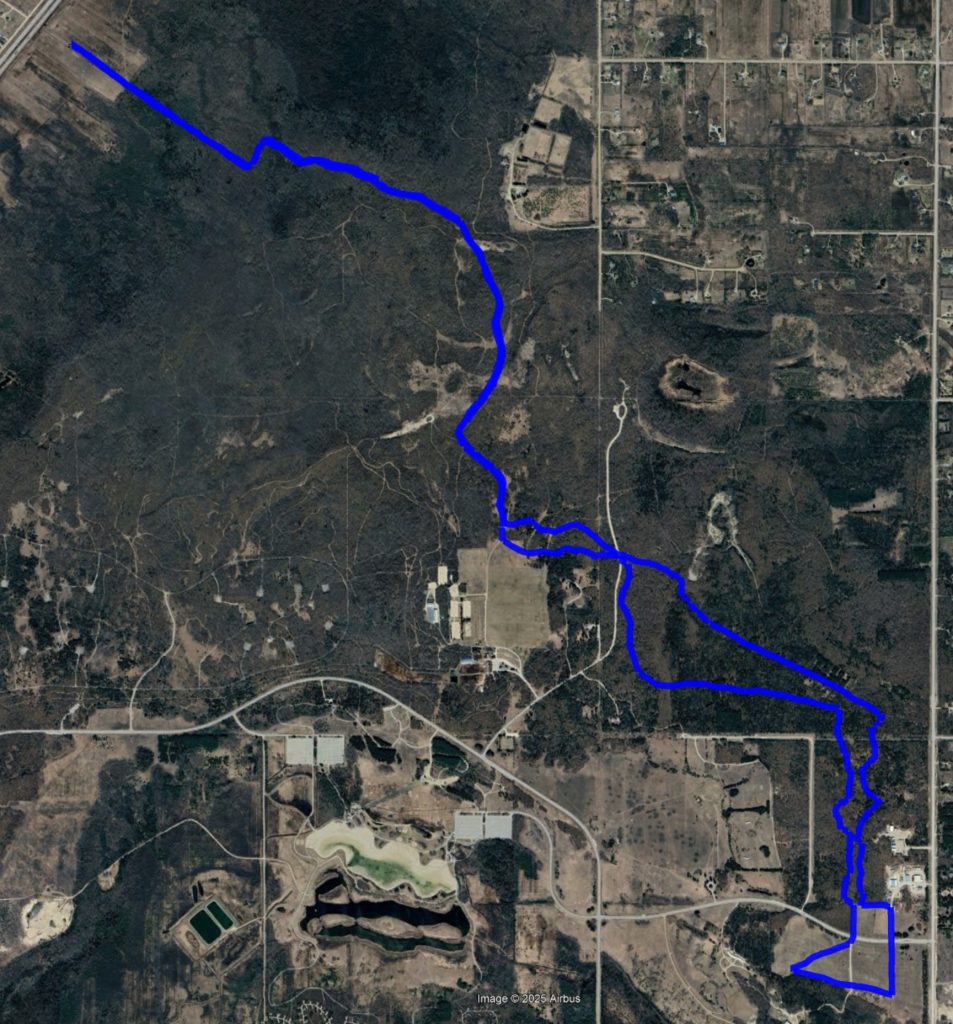
10-mile loop – Blue
You will head out going east of camp towards 206 and then turn north onto the road that takes you to the East Gate parking lot. Continue north to the tree line then make a left turn to head to the red trail (bridle path).
Turn right into the red trail. You will continue on the red trail crossing Nimowin road and going back onto the red trail. You will cross Roscoe Road still on the red trail and take a left heading west. Please note that this is common trail with the 15 mile loop until this point. Make sure you continue straight going west.
You will continue on to the Tamarac trail and make a right turn onto the trail. You will continue all the way down the Tamarack (yellow) until you can see Highway 59. At the map sign close to the highway you will turn and start heading back the way you came. This portion is an out-and-back.
Close to the sand pit area where they circle the polo ponies you will cross over to the blue trail (Lyme Kiln) and you will follow that to the Mosquito Alley turn. You will turn left and follow that trail down to the polo field area turning left to head east. You will head east towards the pink trail. You will be at the north end of the polo field.
Head in on the pink trail back to camp.
GPX links for
10 mile Blue loop: 10 Mile Loop
15 mile Pink loop: 15 Mile Loop
Instructions on how to use GPX files: http://www.distanceridersofmanitoba.ca/DRM/drm-gpx-files-and-info/
15 mile loop – pink ribbons
10 mile loop – blue ribbons
Right turn – red ribbons
Left turn – green ribbons
Ribbons will be on your right-hand side.
Unfortunately, trail sabotage is common in birds hill park and sometimes ribbons are removed. Because of this we ground sprayed the turns.